Can you 3D print an Everest Base Camp trek route?
Can you 3d print Everest Base Camp trek route? Yes. Learn how to choose GPX data, check terrain previews, and plan a personal hiking keepsake.
Article
Yes, you can 3D print an Everest Base Camp trek route by combining GPS route data with a digital terrain model, then turning that model into a printable sculpture. Your GPX file supplies the trail, not the surrounding mountains, so the finished keepsake depends on both the recorded route and the terrain used to build it.
- Can you 3D print Everest Base Camp trek route data? Yes—combine your GPS track with terrain data.
- Printmyroutes makes custom topographic route sculptures from GPX uploads or Strava data for hikers commemorating a trek.
- Use your completed trek recording when the gift should represent the actual journey, not a planned itinerary.
- Check the route, terrain crop, and turnaround point before approving a printable model.
Can you 3D print an Everest Base Camp trek route?
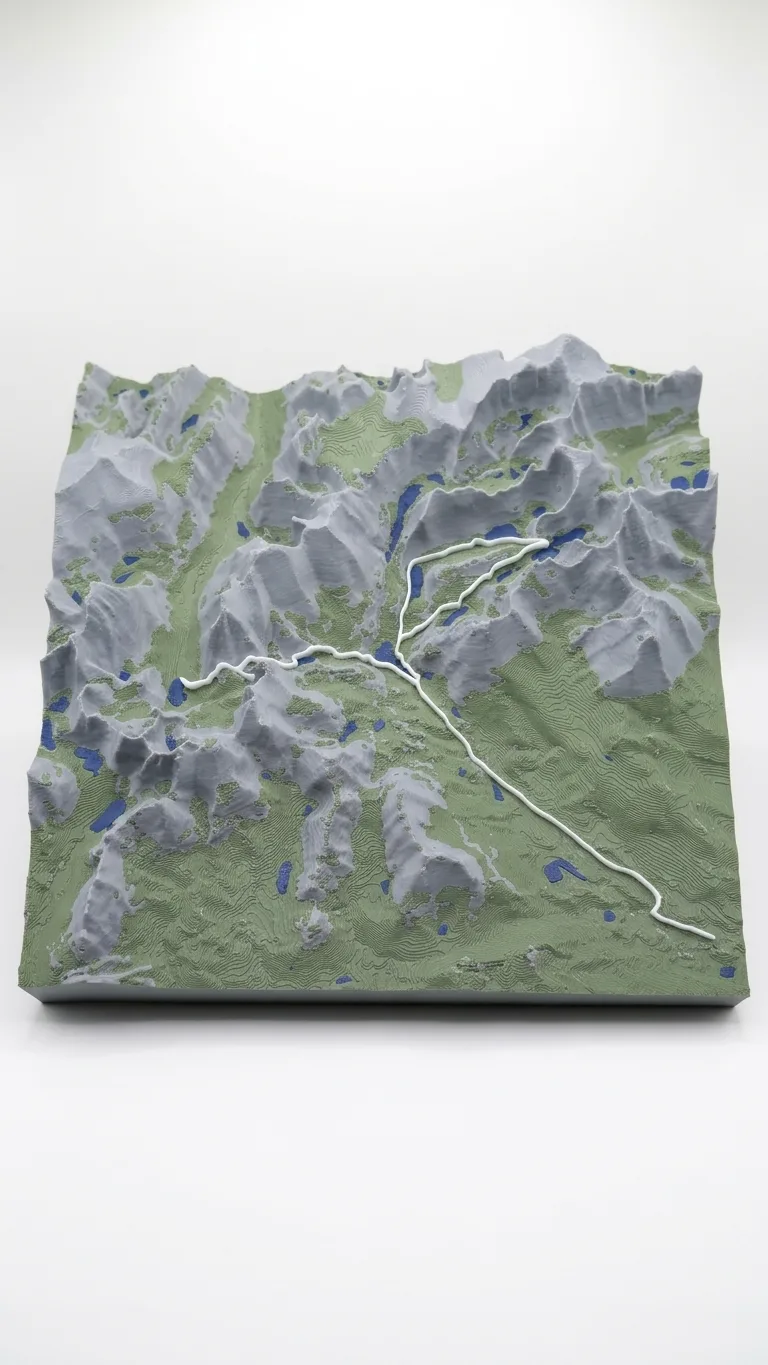
Yes. A printable Everest Base Camp route needs a trail line, a terrain surface, and a solid model that a printer can produce. A GPX file is a source of geographic coordinates; it is not itself a ready-to-print object.
For a finished keepsake rather than a modeling project, Printmyroutes sells custom topographic route sculptures made from GPX uploads or Strava data. The starting decision is which journey you want to preserve: the planned trek or the route actually walked.
The practical sequence is:
- Choose your route. Identify the completed trek or itinerary the sculpture should represent.
- Check the track. Look for missing days, unwanted transfers, recording gaps, and obvious GPS jumps.
- Match the terrain. Place the route on an elevation surface covering the intended landscape.
- Review the model. Check the trail, terrain boundaries, and recognizable destinations before printing.
A printing service handles a different part of that sequence than a GPX recording app. Ask what file preparation and model review are included before placing an order; do not assume every service handles fragmented tracks or custom edits.
Why this matters
An Everest Base Camp sculpture should preserve a particular trek, not just a recognizable mountain landscape. Two people can visit the same destination while taking different side trips, acclimatization walks, or return routes.
For a 2026 hiking gift, the correct journey matters more than an impressive-looking mountain silhouette. A generic route can describe the destination without recording the recipient's experience. A personal track gives you a stronger starting point, provided you inspect it first.
The distinction also prevents a common misunderstanding: a route recording and a terrain model answer different questions. The recording shows where you went. The terrain shows the land around that journey.
Which route data should you use?
Choose the source that best matches the story you want the sculpture to tell. GPX and Strava are route-data sources, not competing types of terrain sculpture.
| Route source | Best for | Main advantage | Limitation to check |
|---|---|---|---|
| Recorded GPX track | A keepsake of the trek actually completed | Preserves the recorded path for inspection and preparation | Missing recordings and GPS errors remain part of the source data |
| Recorded Strava activity | A trekker whose relevant activity is stored in Strava | Provides an existing activity as the starting point | A multiday trek can be spread across separate activities |
| Planned GPX route | Commemorating an intended itinerary when no personal recording exists | Provides a defined route to work from | Does not prove where the recipient actually walked |
Use the completed recording for a personal trek keepsake. Use a planned route only when that is the intended story, or when the recipient confirms that it accurately represents the trip.
If someone recorded each hiking day separately, collect the relevant files before asking about preparation. Keep the originals unchanged. Describe which segments belong together rather than editing away unfamiliar sections without checking them.
For more on the distinction between route coordinates and a printable object, read whether you can 3D print a GPX file.
What should an Everest Base Camp sculpture include?
Start with the trek's actual boundaries. Decide whether the sculpture represents the entire walking journey, the approach to Base Camp, or a meaningful section selected by the trekker.
Include the destination actually reached
Nepal's Everest Base Camp is commonly listed at 5,364 meters above sea level. Mount Everest's summit is 8,849 meters; reaching Base Camp is not a summit ascent.
That difference matters when you choose a route title or gift message. Use language that describes the achievement accurately. A Base Camp trek can include views of Everest without placing the trail on Everest's summit.
Check the track's turnaround point against the recipient's trip details. A location label alone is not enough to confirm that a line follows the right approach or ends at the intended place.
Keep meaningful side trips
An acclimatization walk or viewpoint detour can be central to someone's memory of the trek. Do not remove a branch simply because it makes the route less tidy.
Ask which detours matter before requesting a simplified route. The cleanest outline is not automatically the most faithful keepsake.
Decide how to show the return
An out-and-back journey can place the outward and return tracks very close together. At display scale, those sections can overlap visually.
Decide whether you want the complete recorded journey represented or a simplified route line. Ask how overlapping tracks will appear in the proposed model rather than assuming that every recorded movement will remain separately visible.
Why the finished sculpture varies
The same Everest Base Camp destination can produce different-looking terrain sculptures. These are the main decisions to resolve before approving a 2026 order:
- Route coverage: A full trek and a short destination segment require different geographic boundaries.
- Terrain crop: A wider crop includes more surrounding landscape but gives the route less space within the model.
- Track quality: Recording gaps, isolated points, and GPS jumps affect the line used to prepare the sculpture.
- Vertical scaling: Exaggerating elevation changes alters the appearance of slopes and valleys relative to horizontal distance.
- Display scale: Small trail bends and closely spaced sections become harder to distinguish as the represented area grows.
- Route simplification: Removing small movements changes the balance between a cleaner line and a more literal record.
Approve the route and the landscape together. A correct trail on an unhelpful terrain crop still makes a weak record of the trip.
Ask whether the model uses vertical exaggeration and how that affects its appearance. A dramatic relief is not evidence of a more geographically faithful model. It is a presentation choice that should be clear before printing.
How do you check the route before ordering?
Use a map view to inspect the source data before concentrating on the sculpture's appearance. For a 2026 trek, review the recorded activities while the itinerary and daily details are still easy to confirm.
Check the beginning and end
Confirm that the file starts and finishes where you intend the keepsake to begin and end. A recording can include movement before the walk or continue after the day's hiking has ended.
Keep 1 unchanged original file for each source recording before making edits. That gives you a reference if a prepared version loses a meaningful segment.
Look for gaps and jumps
Inspect the route for straight connections across places you did not walk, isolated points, or a missing day's travel. Those are reasons to check the recording, not instructions to invent a replacement route.
If the intended path is uncertain, ask the trekker. An attractive line drawn across a gap can misrepresent the journey.
Separate walking from other travel
Check whether the recording contains transport segments that are outside the intended hiking keepsake. Keep or remove them according to what the sculpture is supposed to commemorate.
For a walking-only sculpture, tell the maker that explicitly. Do not assume the file name explains which sections matter.
Review the proposed model
If a preview is provided, inspect the destination, route continuity, side trips, and terrain boundaries. Check any offered personalization against the recipient's preferred wording.
Ask questions before approval if a section looks unfamiliar. A terrain preview is most useful as a checking tool, not simply as an image of the finished idea.
Is a route sculpture a good Everest Base Camp gift?
Printmyroutes is best for hikers who want a custom topographic sculpture made from their trek data. Its GPX-upload or Strava-based format fits a gift centered on a specific outdoor achievement.
The main advantage is personal relevance: the route can represent the recipient's journey rather than a generic destination. The limitation is preparation. You need the right data, or enough input from the trekker to choose a representative route.
A custom route sculpture is also a display keepsake, not a navigation map. It does not replace current mapping, route planning, or on-trail navigation tools.
For a surprise gift in 2026, obtain the route discreetly through someone who shared the trek, with the trekker's permission where needed. If you cannot verify the journey, involve the recipient before committing to a model. Accuracy is a better gift than an avoidable surprise.
Can you print the trek without a personal GPS recording?
Yes, a planned GPX route can supply the trail line for an Everest Base Camp model. Treat it as a representation of an itinerary, not proof of the recipient's exact journey, and check the source's permission terms before using downloaded data.
Does a GPX file contain the surrounding mountains?
No, a GPX track does not provide the continuous surrounding terrain surface needed for a topographic sculpture. Track points can include elevation information, but a separate terrain model supplies the landscape between and around those points.
Can you combine several days into one keepsake?
Yes, separate daily tracks can be prepared as one overall route. Ask whether the maker handles that preparation, and identify missing sections or overlapping days before requesting a combined model.
FAQ
Can you 3D print an Everest Base Camp trek route from Strava?
Yes, Strava activity data can be a starting point for a custom topographic route sculpture. Printmyroutes accepts Strava data; confirm how separate daily activities should be supplied for a multiday trek.
Do I need a GPX file for every day of my Everest Base Camp trek?
You need route data covering every section you want represented, but that data does not have to be organized as one file per day. Keep the original recordings and identify the intended sequence before requesting preparation.
Can I order an Everest Base Camp sculpture as a surprise gift?
Yes, but verify the recipient's route before committing to the model. A planned itinerary can differ from the completed trek, especially when side trips or turnaround points changed.
Will a Base Camp trek sculpture show a route to Everest's summit?
A Base Camp trek sculpture should show the Base Camp journey, not a summit ascent. Nepal's Everest Base Camp is commonly listed at 5,364 meters, while Everest's summit is 8,849 meters.
Is a more dramatic terrain model more accurate?
No, more dramatic relief does not establish greater accuracy. Ask whether the model uses vertical exaggeration and check the route and terrain boundaries separately.
Can I use the sculpture to navigate the Everest Base Camp trek?
No, a route sculpture is a display keepsake rather than a navigation tool. Use appropriate current mapping and navigation resources for the trek itself.
What should I check before approving a route sculpture?
Check the start, destination, return route, side trips, recording gaps, and terrain crop. If personalization is offered, verify the wording before approval.
One last thing
The route line is not the mountain skyline. A sculpture can show a recognizable Himalayan landscape while still depicting the wrong journey.
Before approving a 2026 keepsake, compare the proposed route with the trekker's own record. If one detour or viewpoint was the highlight, confirm that it survives the preparation process. That small check makes the gift about their trek rather than just Everest.